steve@buildingsurvey.co.uk
0330 133 1111
34 Queen Street Derby DE1 3DS
8.30am to 6.30pm Monday to Friday
Home
RICS Expert Witness Reports
Boundary Disputes
Experience
Contact
NOTTINGHAM DERBY RICS BOUNDARY SURVEYOR INDEPENDENT EXPERT REPORT FOR A BOUNDARY DISPUTE
This concerned a plot of land adjacent to a semi detached house. The land had once belonged to the house and had been sold as a development plot in about 2006. The purchaser of the land had started to construct a fence along the side of the path that lead to the house as per planning application and with full knowledge of the vendor who still owned the house at that time. The development was then abandoned, but a new owner of the house from 2009 moved the fence to a line that appeared to be randomly chosen. The movement of the fence limited the size of house that could be developed on the plot and the dispute went to trial. The owner of the development plot was somewhat over confident and failed to appoint a barrister until hours before the trial. The barrister was all at sea. The judge had originally suggested that the fence at the side of the path was correct but was persuaded to side with the new house owner. The judge seems to have been much persuaded that the conveyance plan of the development plot might exclude a demolished coal store and that the coal store was accessed from the house.
Click image for larger plan
Click image for larger plan
Click image for larger plan
Click image for larger plan
Click image for larger plan
Click image for larger plan
Click image for larger plan
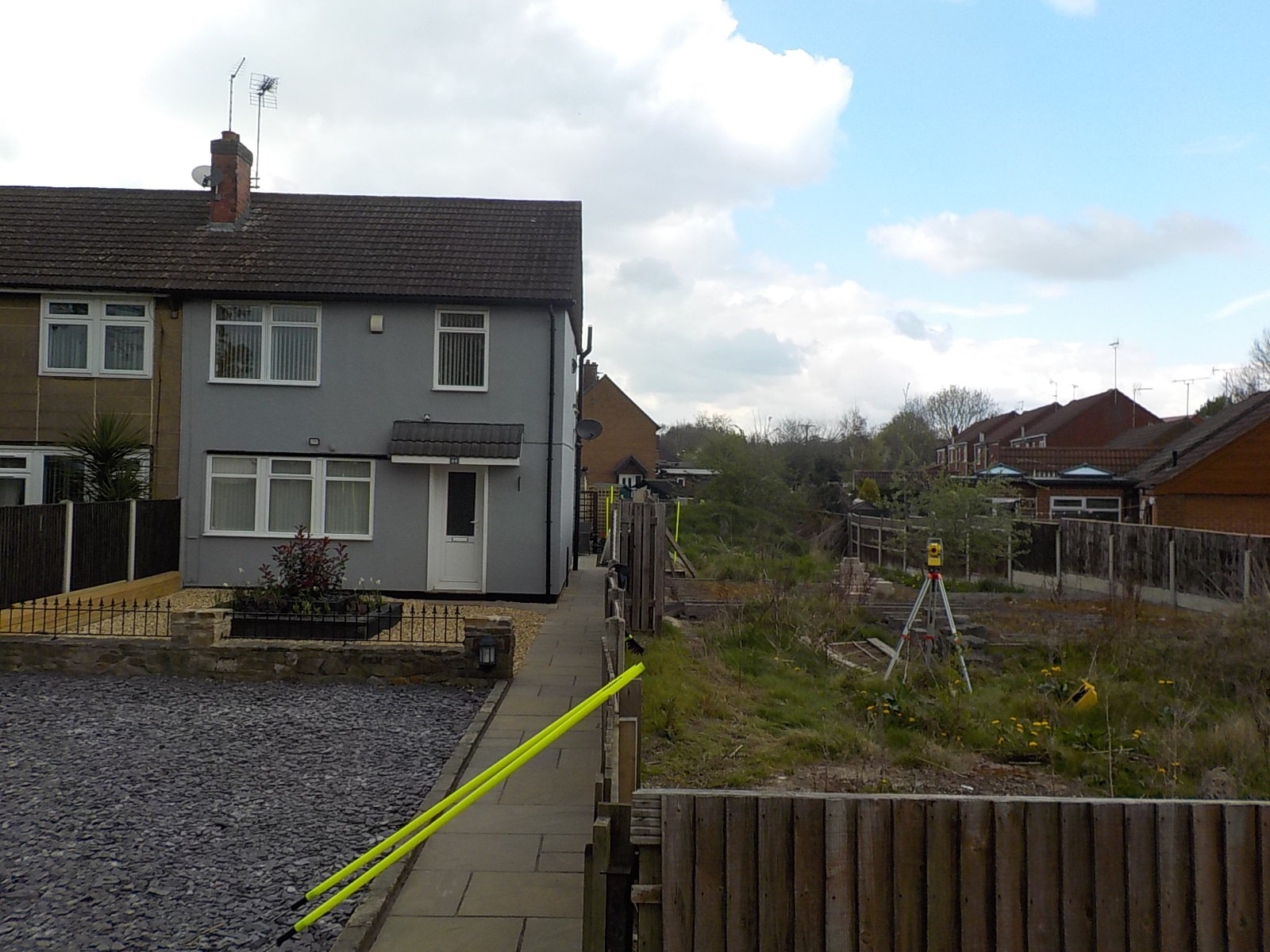
Front of the house with development plot at the side. Path edge is the original fence line
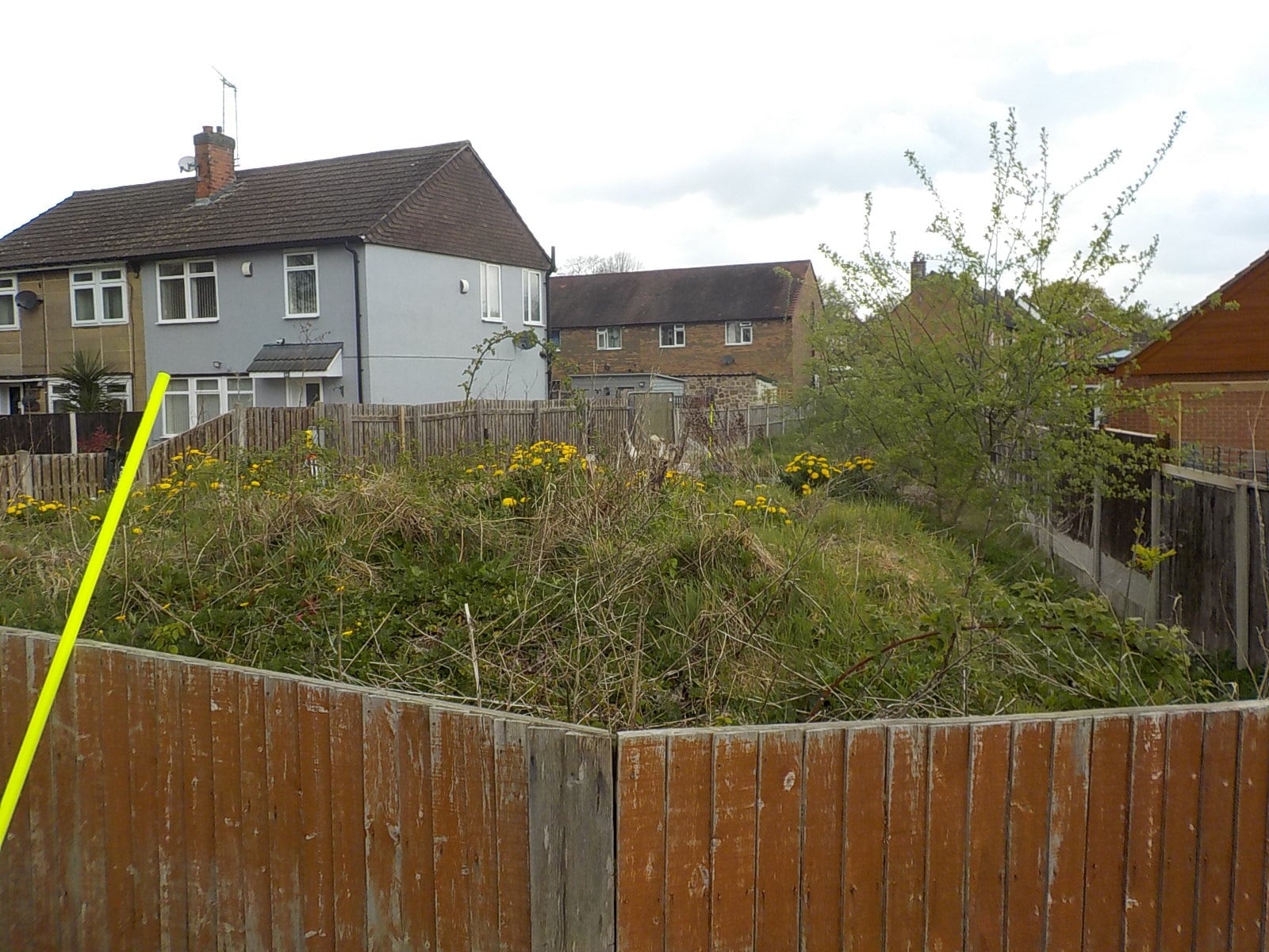
View of the development plot
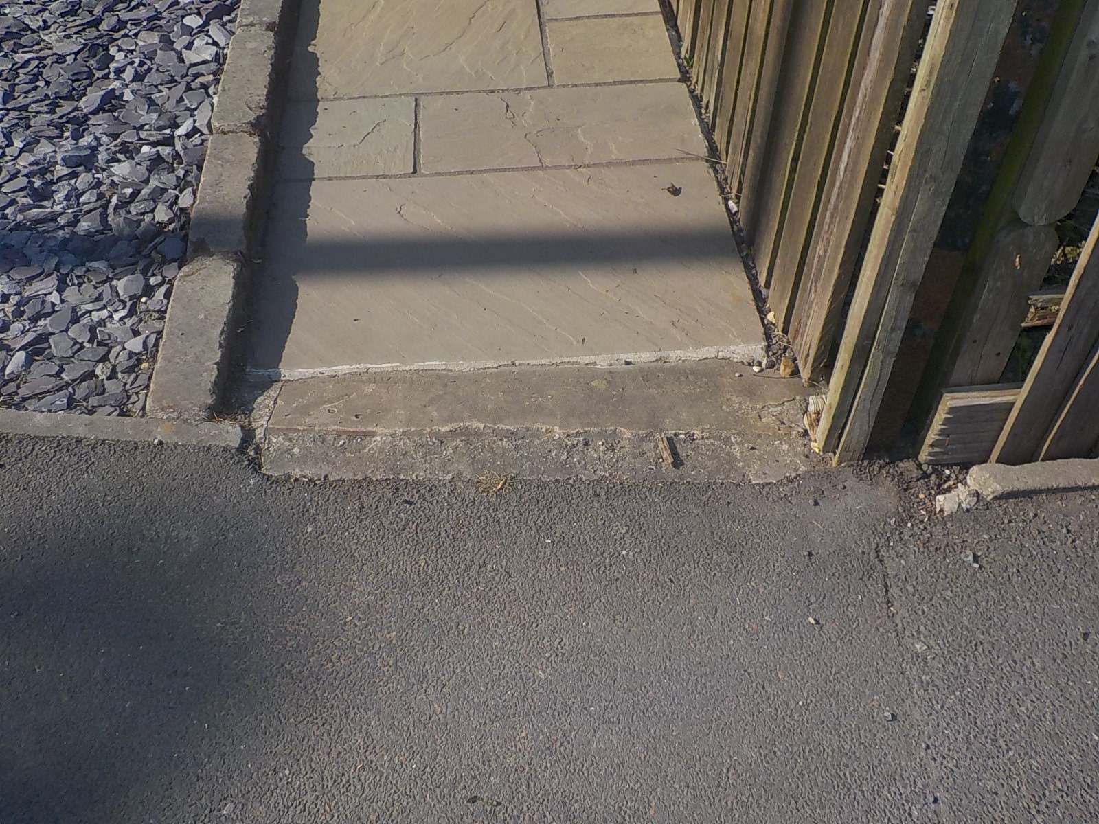
Features from original entrance gate
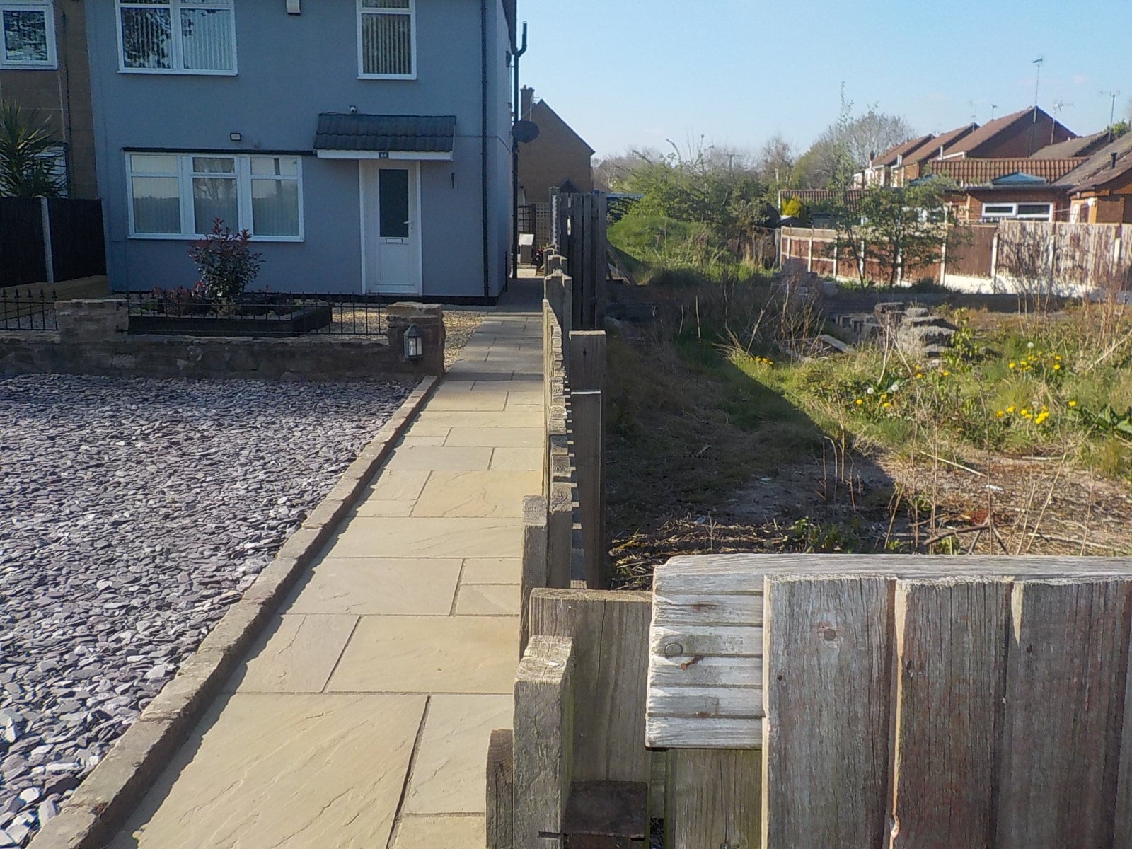
General view of the fence
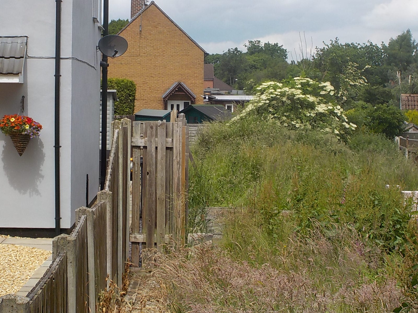
The step in the fence introduced by the new owner of the house
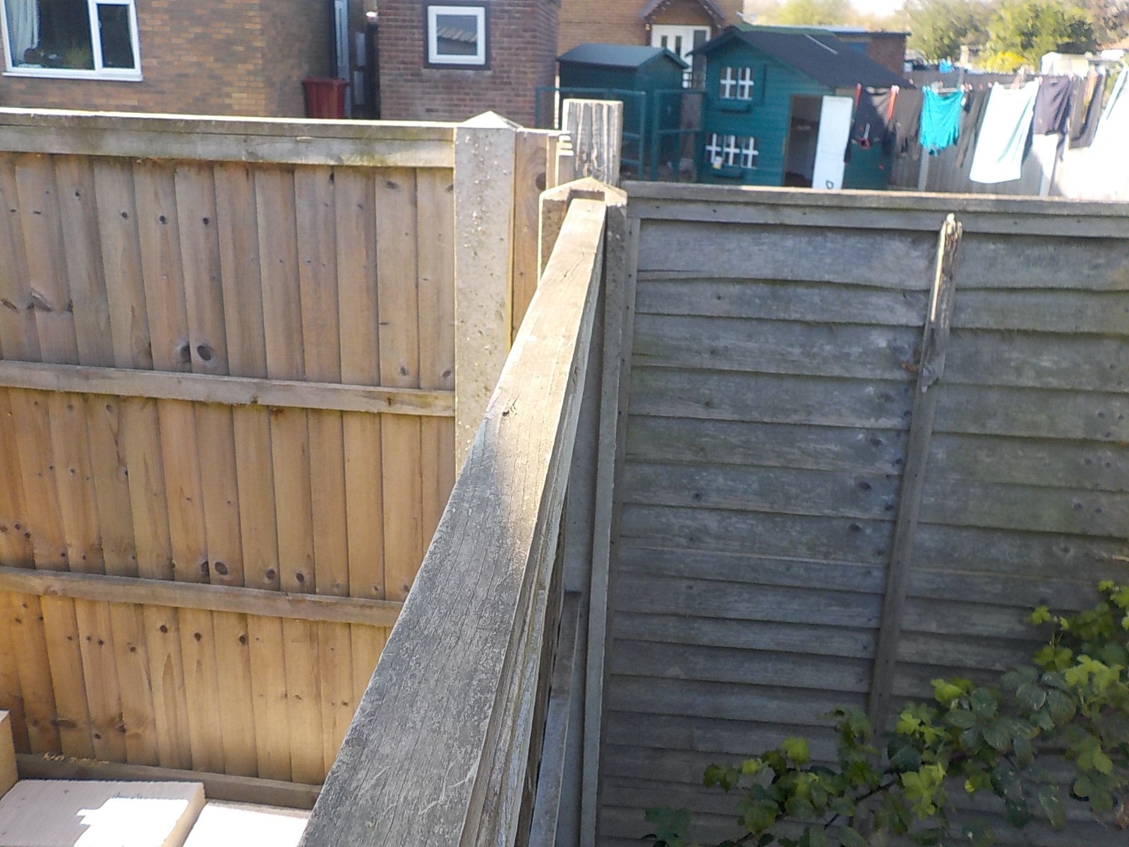
End of the fecne at the rear.
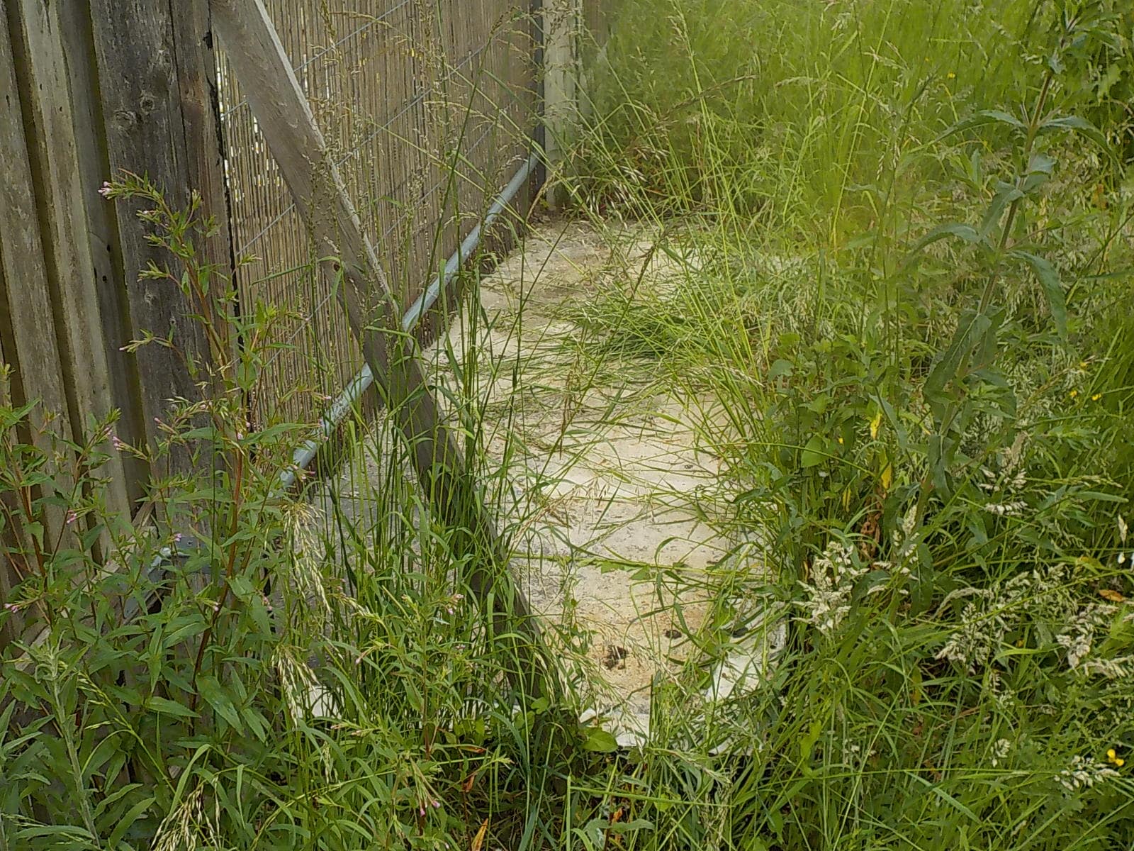
Demolished coal store. Door once faced the house
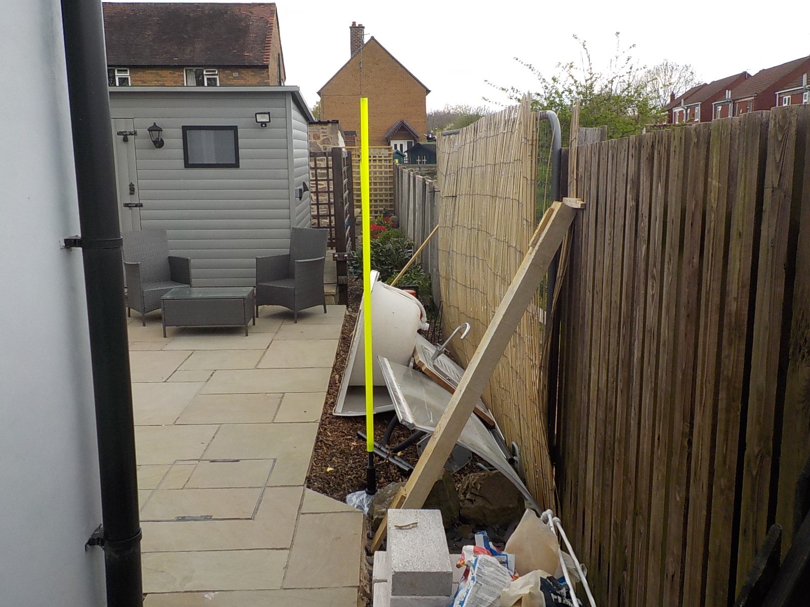
The yellow pole is on another corner of the coal store
29th April 2022
The County Court
- 64 Gate Lane and Land Adjacent
- Thank you for your instruction to prepare a single joint expert report into the location of the boundary between the two properties.
- Conflicts of Interest
- I have not acted for either party before.
- Qualifications
- I am Steven John Macgregor Butler, a Member of the Royal Institution of Chartered Surveyor trading as a sole practitioner. I qualified in 1992 and have in excess of ten years’ experience of preparing reports on boundaries and rights of way. CV attached as Appendix 1.
- Law
- Mr Justice Barker summarised much of the boundary law that had gone before in the case of Acco and Severn in 2011. I shall follow his guidelines for determining a boundary as I do in preparing any reports on boundaries.
- Comments of Mr Justice Barker:
- ‘Before turning to the facts and expert opinion evidence, I should briefly remind myself of the principles relevant to determination of boundary disputes, at least insofar as they are potentially applicable to this case:
- Where, as in this case, the property in question is registered land, the file plans show only general boundaries and not the exact line of the boundaries unless the property is said to be “more particularly described in the plan.”
- Similarly, Ordnance Survey plans, if not forming part of the registered title as filed plans, are no more than a general guide to a boundary feature, and they should not be scaled up to delineate an exact boundary. This is because the lines marking the boundaries become so thick on being scaled up as to render them useless for detailed definition.
- In order to determine the exact line of a boundary, the starting point is the language of the conveyance aided, where the verbal description does not suffice, by the representation of the boundaries on any plan, or guided by the plan if that is intended to be definitive.
- If that does not bring clarity, or the clarity necessary to define a boundary, recourse may then be had to extrinsic evidence - such as topographical features on the land that existed, or maybe supposed to have existed, when the dividing conveyance was executed.
- Admissible extrinsic evidence may also include evidence of subsequent conduct where of probative value in showing what the original parties intended.
- Evidence of later features - that is, later than the earliest dividing conveyance - may or may not be of relevance. The probative significance of such evidence depends upon the extent to which, if at all, the dividing conveyance, or evidence of its terms, exists.
- Where a boundary is in dispute, it is important to bring certainty to the determination by proclaiming the boundary and not leaving the plot “fuzzy at the edges” (Neilson v Poole (1969) 20 P&CR 909, Megarry J).
- Even where a boundary line may be determined by reference to a conveyance, other evidence may be admitted and probative in establishing a different boundary obtained by adverse possession, showing enclosure of the land in denial of the title of the true owner. As the phrase implies, title is established by intentionally taking exclusive possession of land without the consent of, and adverse to the interests of, the true owner, and maintaining such possession continuously for the limitation period.
- As to informal boundary agreements, the statutory requirement that contracts for the sale or other disposition of land be in writing does not apply. That is because the purpose of such agreements is to demarcate an unclear boundary referred to in title documents and not to transfer an interest in land.
- Such agreements are usually oral and the result of neighbours meeting to avoid or resolve a potential or actual dispute. However, there is scope for a boundary agreement to be implied or inferred - that is, to be the logical conclusion to be drawn from primary facts.
- When bearing these principles in mind as the platform on which to place and examine the facts, a judge should have regard to three further important yardsticks or rules of thumb. These are: (1) when considering any acquisition of property, it is vital to consider what a reasonable layman would think he was buying; (2) every case turns on its own facts; and (3) the task of the court is to assess all available and admissible material in arriving at its answer, and then to achieve the correct answer.
- Documents
- The following documents may also be relevant to the matter:
- Conveyance of 17th December 1990 of 64 Gate Lane and the Adjacent Land Appendix 2. I have included it because it shows drains mentioned in the applicants claim form.
- Conveyance of 2004 (Precise date illegible) in respect of the Land Adjacent. Appendix 3. This is the document dividing the land.
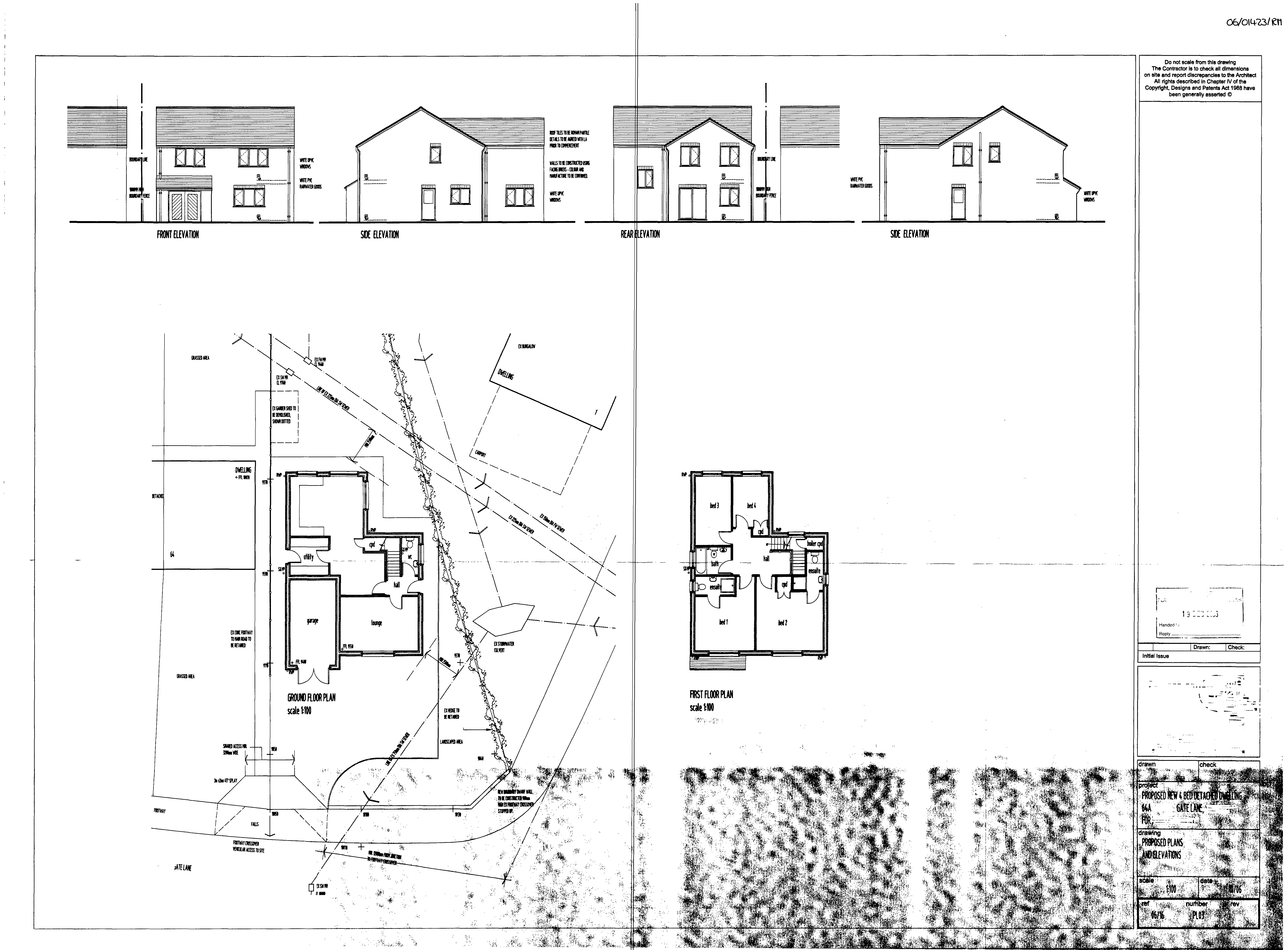
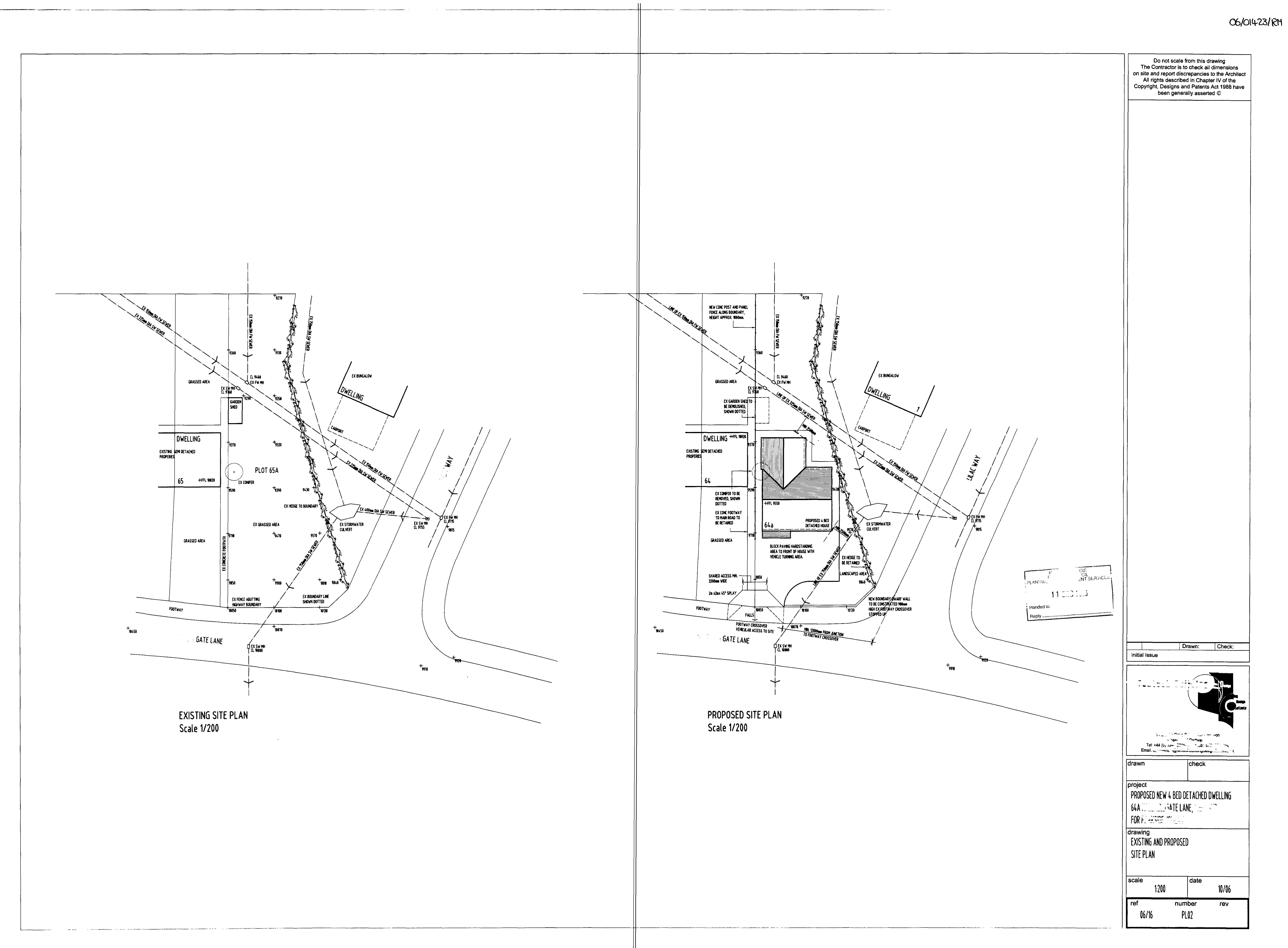
- Plan from a November 2006 Planning application for the Adjacent Land. Appendix 4.
- Photographs
- Annotated photographs follow the report at Appendix 5 and prior reference to them may enable a reader to follow the report more easily.
- Historic photographs are shown at Appendix 6
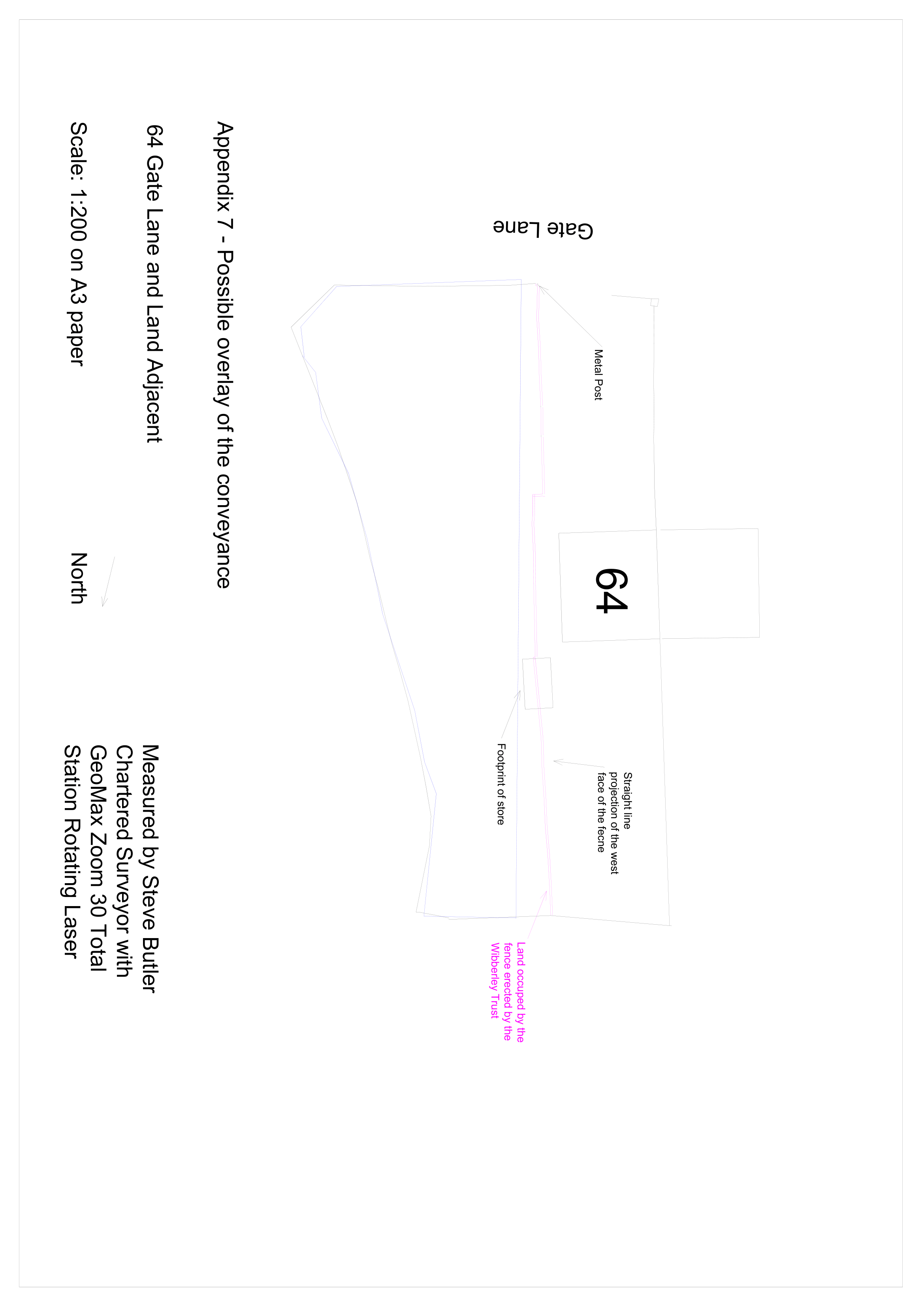
- A plan showing the currently layout of the site is attached at Appendix 7. Please note the north and west boundaries of the existing 64 are estimated as they could not be seen by the laser measure.
- Background
- 64 Gate Lane and the Adjacent Land were purchased by a Mr and Mrs Yates from the local authority 17th December 1990 as one property.
- The house purchased was a semi-detached house of concrete panel construction and a type declared defective under the Housing Defects Act 1984.
- It had a concrete path that ran from the pavement immediately adjacent to the east wall of the property. Close to the east of the path and slightly to the rear of the property was a coal store.
- It is not clear from photographs if the coal store abutted the edge of the path was set back or set into the line of the path.
- At some time after, probably June 2001, 64 Gate Lane and the Adjacent Land came into the possession of Dr Karen Ann H.
- It is not entirely clear to me the order of events but it seems that Dr H agreed to sell the Adjacent Land to TLF Developments.
- An agreement to sell the Adjacent Land was dated 2004 (it has been suggested 4th August) and was subsequently registered at the Land Registry with accompanying plan that appears to be dated 24 January 2006. Land Registry despite the 2004 date describe it as a conveyance dated 16th August 2006.
- The plan is remarkably badly drawn given that the text of the document states that the land transferred is defined by it.
- The plan and text of the conveyance suggest that the purchaser is to fence the boundary between The Adjacent Land and Number 64. There is no mention of rights or reservations in respect of drains.
- Although I cannot see it written in the document lodged with the Registry it seems that the parties in-fact entered into agreement for TLF to purchase subject to planning.
- The Land Register suggests that a sum of £60,000 was paid for the Adjacent Land 16th August 2006 but I have not seen a supporting document.
- Derbys planning register suggests that a series of planning applications were made.
- Dr H made an outline application for a dwelling which also include a proposal to moving an existing entrance to the Adjacent Land so that it would be shared with 64 in October 2005.
- Consent was granted to Dr H 16th February 2006 subject to reserved matters.
- A detailed application for a detached house was then made by PJ (Presumably related to TLF) 15th November 2006.
- A plan of the site as ‘Existing’ at that time of the November 2006 application suggests that the boundary of the two properties ran adjacent to the concrete path leading to Number 64 the east boundary of which was in line with the west face of a now demolished coal store.
- A plan of the ‘Proposed Development’ suggests that a coal store previously belonging to 64 will be demolished and shows a fence separating the Adjacent Land from 64 running on a line approximating to the west face of the coal store as in the plan of the site as ‘Existing’.
- Very similar applications were made 6th July 2007 and 11th April 2008. Both were conditionally approved.
- The applications are consistent in that the boundary of the proposed development follows the line of the concrete path at 64 and the west face of the coal store. The coal store is to be demolished.
- Of course, the planning application does not define the boundary and it is possible that the plans were not particular well drawn or that TLF were mistaken as to what they had purchased.
- Google Street View suggests that by July 2009 construction had commenced and that the posts for a fence running along the edge of the access path to 64 had been erected. The fence did not continue past the coal store. The fence appears from the limited inspection possible from the Google Street View Photograph to finish close the west face of the coal store but it is not clear if it is in alignment.
- I have not been provided with or able to obtain from the internet any photographs of the property at the time of either the 2004/2006 or 2009 sales.
- The W Trust purchased Number 64 from Dr H 18th December 2009. The price paid was also £60,000.
- At some time after purchase the W Trust clad the house with external insulation that is about 40m thick and altered the fence between Number 64 and Adjacent Land.
- The cladding does not appear to have affected the dimensions of the original house. It projects about 40mm beyond the concrete base of the house.
- Landscaping works have hidden or removed the concrete path but a metal post at the pavement edge marks its abutment with the pavement.
- The W Trust appear to have used six of the existing concrete posts to construct their fence removing the one nearest to the road and those at the side of the house. Just in front of and at the side of the house the fence steps out slightly and then meanders passing through the middle of the former coal store continuing to the rear boundary of the two properties.
- The act of altering the fence has created the dispute.
- The rear boundaries of 64 and the Adjacent Land have different fences. They meet at the end of the disputed fence. The fence at the rear of the Adjacent Land is older and at a lower level then that at 64.
- Inspection
- The Adjacent Land and 64 Gate Lane were measured with a Geomax Total Station the points collected being used to draw a plan with BricsCAD. Some points were measured by hand.
- Analysis
- Intrinsic Evidence
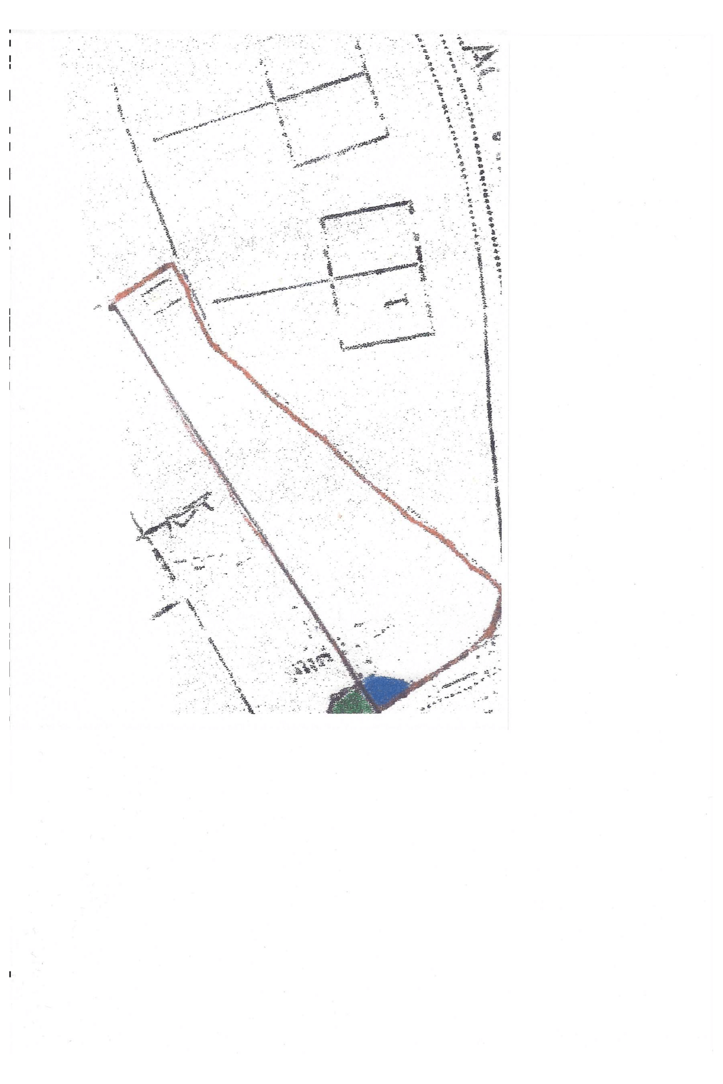
- The 2004/ 2006 Conveyance Document defines the Adjacent Land by reference to a plan.
- The plan appears to be derived given some of the annotation and date from one used as part of a planning application by Dr H. Whilst it has some measurements, they are not sufficient to calculate the point at which the boundary intersects with the pavement, and the coal store is not shown.
- I suspect that the plan is based on the 1:1250 OS sheet but it has been distorted and has no scale.
- Whilst the intrinsic evidence might be the starting point for the Court, I consider that the plan is useless to try and determine the boundary with any accuracy.
- I cannot envisage that the draftsman envisaged that anybody would try and scale the boundary from it or use some other mathematical method to determine the boundary.
- The Land Registry have interpreted the plan to create a Title Plan but they only need to show a General Boundary.
- The Court might thus like to venture further and consider the extrinsic evidence.
- However before doing this, it should be said that the extremes of the fence erected by the W Trust are not an unreasonable interpretation of the plan.
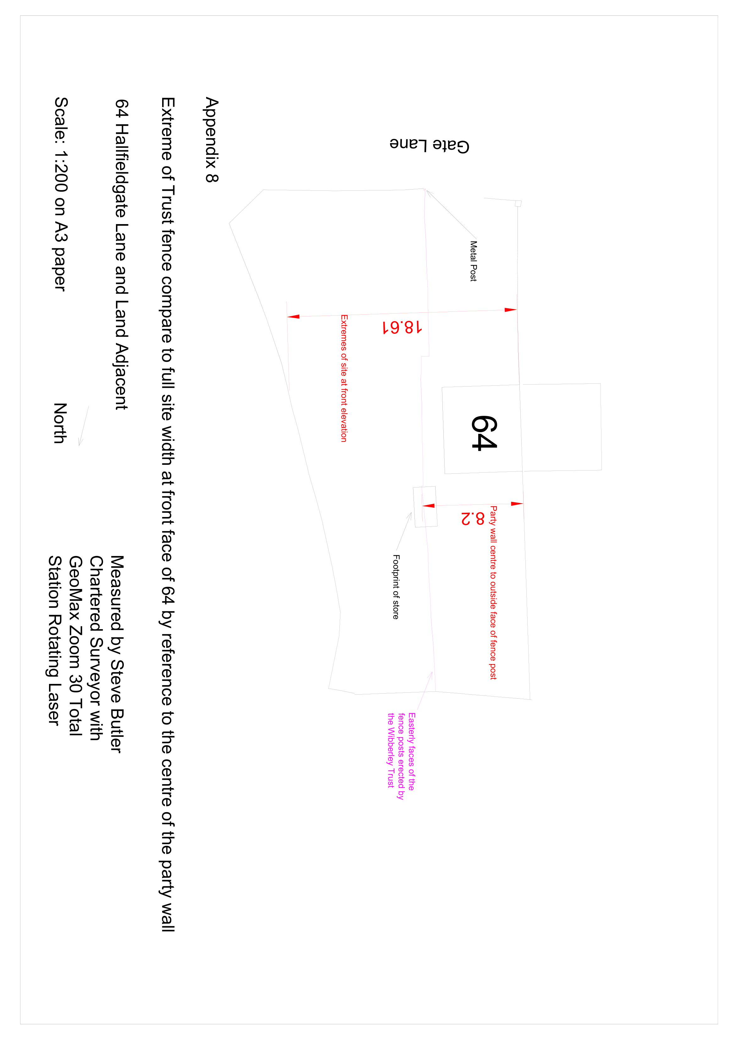
- The east most faces of the fence posts erected by the W Trust are about 1.95m from the face of the house. This is about 43% of the total width of the original plot measured from the centre of the party wall with 66 across the front elevation of 64. Appendix 8.
- The conveyance plan suggests that the measurement from the party wall with 66 to the boundary separating the Adjacent Land was 45% of the total width of the site at the front elevation of the house at 64.
- By comparison with the width of the house at Number 64 the line drawn on the conveyance plan might be up to 2.0m from the face of the house.
- If only the land within the red lines of the conveyance plan is considered, it is possible to interpret the boundary as approximating to the eastern elevation of the demolished coal store by placing a blow up of the conveyance plan against the eastern boundary of my plans. Appendix 11. Other features such as the house at 64 would not align.
- Whilst the boundary drawn on the conveyance plan weaves the whole length of it approximates to a straight line.
- There is nothing about the line drawn on the plan that suggests to me that there is a step, or steps in the boundary to accommodate the perimeter of the coal store.
- I am doubtful that the fence erected by TLF is a reasonable interpretation of the plan if extrinsic evidence is disregarded.
- The conveyance plan might also be interpreted in other ways.
- Extrinsic Evidence
- It is interesting that the £60,000 paid for Number 64 in 2009 was the same as the price paid for development plot in 2006.
- There was thus every incentive for Dr H to maximize the width of the development plot at the expense of Number 64. The width of the plot would be important in deciding whether a lucrative four-bedroom house could be built instead of a three bedroom one.
- The three-planning applications submitted by PJ were all consistent with this.
- By June 2009 a fence had been erected between the road and coal store following the edge of the concrete path. Whilst its exact course is hard to determine I think that it might be described on casual inspection as being in an approximately straight line and as close to the path as practicably possible.
- The W Trust in their defence agree with the claimant that by November 2009 some timber panels had been added to the fence.
- The fence ran from a metal post adjacent to the path at the pavement edge to just inside the west face of the coal store although it is not possible to say whether it was flush with the face of the coal store or set slightly within. Coal stores in similar nearby properties do not particularly relate to their paths.
- The metal post is unlikely to be original. Similar properties have round gate posts set between two concrete posts.
- They state that the existing fence follows the alignment of the original fence (I presume they mean, and comparison of the Google Street View photographs suggests as far as just before the front of the house).
- Whilst no trace of the subject property’s path remains the paths in nearby properties are three feet wide (0.91m), and laid directly against the concrete bases of the nearby properties.
- The slabs laid by the W Trust are three feet wide and all but abut the fence.
- Dr H would have had to have been the most remis property owner not to have been aware of the planning applications being made on the Adjacent Land, particularly as she had sold it for development, or not to have noticed the erection of the concrete fence posts adjacent to her concrete path.
- Having said this from what I can see from the Local Planning Authority records of consulting neighbours for the various applications they consulted everybody but Number 64, perhaps not recognising that the applicant had changed.
- There is no indication that Dr H considered that there was a boundary dispute, and if there had been she would have been obligated to disclose it in the Vendors Questionnaire.
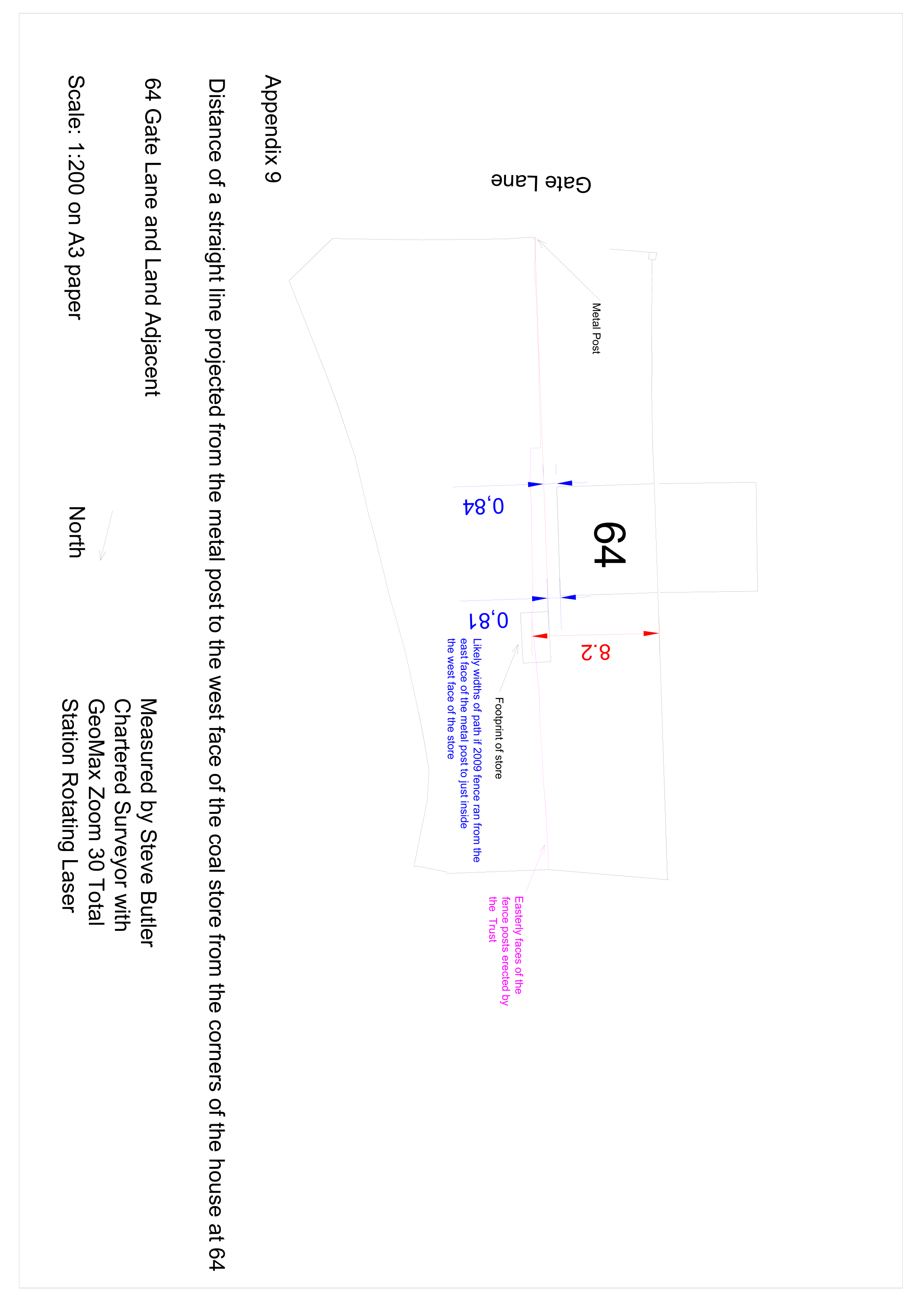
- A line projected from the metal gate post to the west face of the coal store passes the side of the house at just over 0.8m. Appendix 9.
- If this was the boundary it would be unclear if the line then followed the west face of the store or ran slightly within it.
- That the different rear fences of 64 and the Adjacent Land are at different levels and meet at the end of the disputed fence might be indicative that the end of the disputed fence is in the correct position.
- Looking from the metal post the juncture of the three fences is slightly out of alignment with the section of the disputed fence running adjacent to 64’s path.
- However, I suspect that the juncture the fences at the north of the site almost aligning with south section of the disputed fence is just a coincidence, and the different levels explained by works carried out at either 64 or the Adjacent Land.
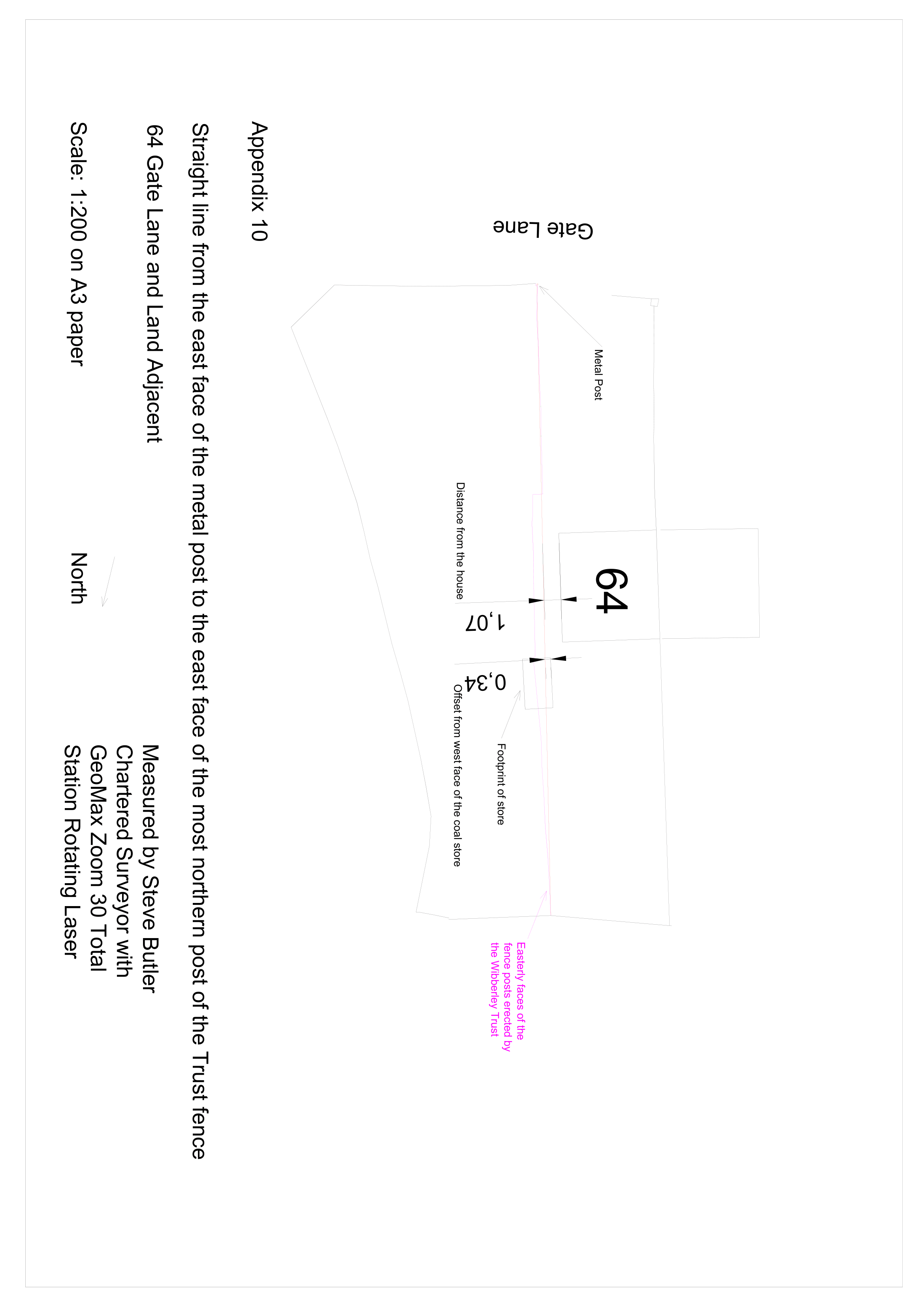
- It is however possible that the boundary passed slightly within the coal store, about 150 to 200mm and on to the northern end of the existing fence. Appendix 10.
- Adverse Possession
- The common law can not be applicable to this matter.
- The disputed land would be one where application for adverse possession could be made under the 2003 Land Registration Act, but I understand that the applicants issued proceedings just before the ten-year qualification period expired.
- Boundary Agreements
- None known.
- What the parties thought that they were purchasing.
- The conveyance plan could be interpreted to show a boundary approximating the extremes of the W Trust fence.
- In the absence of documents to the contrary such as estate agent’s particulars potential purchasers of Number 64 or Adjacent Land are likely to have considered the boundary to be:
- A line approximating to edge of the concrete path in alignment or just within the west face of the coal store as later indicated by the fence.
- As immediately above but including the coal store as it was accessible from 64.
- A line approximating to the east face of the coal store on the grounds that you could access the store from 64 projections of its eastern face might be the boundary.
- The Court may be able to think of other permutations.
- I find it hard to believe that there was no explicit discussion about the coal store at the time the W Trust purchased the property given that it projected beyond the concrete fence.
- Conclusion
- Dr H could have sold a plot of any width or shape.
- She could not sell the same land twice. The W Trust can only have purchased what was left.
- The 2004/2006 conveyance plan is useless for determining the boundary accurately.
- The extremities of the W Trusts existing fence are a reasonable interpretation of the plan using ratios.
- The eastern face of the coal store being the boundary is a reasonable interpretation of the plan if everything outside of the red lines is excluded when considering the plan. Appendix 11.
- I find it harder to consider that the fence erected by TLF was a correct interpretation of the plan, but given the lack of care drawing it, the plan it may be wrong.
- If the TLF fence was the boundary, then given that the coal store was accessible from 64 it might reasonably be considered that it was a projection into the adjacent land.
- The concrete fence would have been a strong indication of the likely boundary to a purchaser of Number 64 in 2009. As its position conflicts with that of the coal store and its accessibility, it is hard to believe that it did not lead to discussion about the line of the boundary.
- The actions of TLF and in action of Dr H contradict the intrinsic evidence and are consistent with the edge of the concrete path having been considered to be the boundary.
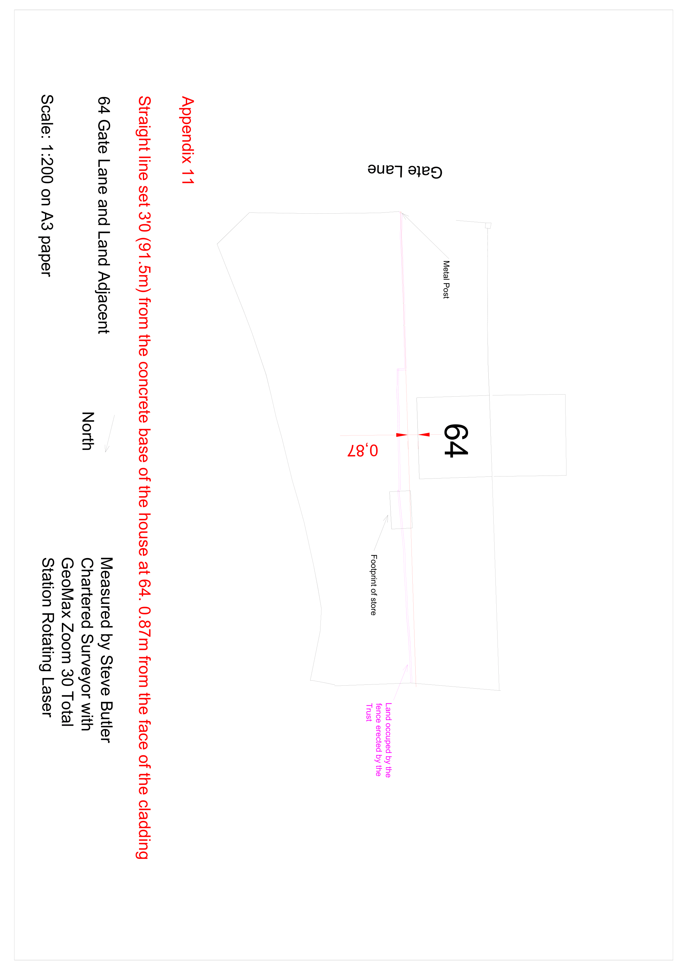
- If the edge of the original path is considered to be the boundary and that it most probably ran about 91.5 cm (Three feet) from the concrete base of the house. Appendix 12.
- As the planning applications suggest that the coal store was to be demolished, I see no reason why the boundary should divert once reaching it.
- The parties may wish to suggest other boundary lines to the court and I am happy to try and draw these on a plan to assist the parties.
- Whether the intrinsic evidence should be disregarded due to the conflicting extrinsic evidence is ultimately a matter for the Court.
- Other information
- Past Owner of the House
- Her planning agent
- Solicitors are more likely to be more skilled in interviewing and obtaining witness statements from these people should they agree.
Statement of Truth
This report is prepared in accordance with the Royal Institution of Chartered Surveyors Expert Witness Practice Statement. Appendix 12.
I Steven JM Butler DECLARE THAT:
1. I understand that my duty in providing written reports and giving evidence is to help the Court, and that this duty overrides any obligation to the party by whom I am engaged or the person who has paid or is liable to pay me. I confirm that I have complied and will continue to comply with my duty.
2. I confirm that I have not entered into any arrangement where the amount or payment of my fees is in any way dependent on the outcome of the case.
3. I know of no conflict of interest of any kind, other than any which I have disclosed in my report.
4. I do not consider that any interest which I have disclosed affects my suitability as an expert witness on any issues on which I have given evidence.
5. I will advise the party by whom I am instructed if, between the date of my report and the trial, there is any change in circumstances which affects my answers to points 3 and 4 above.
6. I have shown the sources of all information I have used.
7. I have exercised reasonable care and skill in order to be accurate and complete in preparing this report.
8. I have endeavoured to include in my report those matters, of which I have knowledge or of which I have been made aware, that might adversely affect the validity of my opinion. I have clearly stated any qualifications to my opinion.
9. I have not, without forming an independent view, included or excluded anything which has been suggested to me by others, including my instructing lawyers.
10. I will notify those instructing me immediately and confirm in writing if, for any reason, my existing report requires any correction or qualification.
11. I understand that –
a. my report will form the evidence to be given under oath or affirmation;
b. questions may be put to me in writing for the purposes of clarifying my report and that my answers shall be treated as part of my report and covered by my statement of truth;
c. the Court may at any stage direct a discussion to take place between experts for the purpose of identifying and discussing the expert issues in the proceedings, where possible reaching an agreed opinion on those issues and identifying what action, if any, may be taken to resolve any of the outstanding issues between the parties;
d. the Court may direct that following a discussion between the experts that a statement should be prepared showing those issues which are agreed, and those issues which are not agreed, together with a summary of the reasons for disagreeing;
e. I may be required to attend Court to be cross-examined on my report; and
f. I am likely to be the subject of public adverse criticism by the judge if the Court concludes that I have not taken reasonable care in trying to meet the standards set out above.
STATEMENT OF TRUTH I confirm that I have made clear which facts and matters referred to in this report are within my own knowledge and which are not. Those that are within my own knowledge I confirm to be true. The opinions I have expressed represent my true and complete professional opinions on the matters to which they refer.
I understand that proceedings for contempt of court may be brought against anyone who makes, or causes to be made, a false statement in a document verified by a statement of truth without an honest belief in its truth
Yours faithfully
Steve Butler
SJM Butler

14th March 2022
BOUNDARY DISPUTE NOTTINGHAM DERBY
NOTINGHAM DERBY BOUNDARY AND RIGHT OF WAY DISPUTE SURVEYS BY RICS SURVEYORS


